Next: 4.4.3 Map frame and
Up: 4.4 Standardized command line
Previous: 4.4.1 Data domain or
Contents
Index
This option selects the coordinate transformation or map projection. The general format is
- -J
 [parameters/]scale. Here, is a lower-case
letter of the alphabet that selects a particular map projection, the parameters
is zero or more slash-delimited projection parameter, and scale is map scale given in
distance units per degree or as 1:xxxxx.
[parameters/]scale. Here, is a lower-case
letter of the alphabet that selects a particular map projection, the parameters
is zero or more slash-delimited projection parameter, and scale is map scale given in
distance units per degree or as 1:xxxxx.
- -J
 [parameters/]width. Here, is an upper-case
letter of the alphabet that selects a particular map projection, the parameters
is zero or more slash-delimited projection parameter, and width is map width (map
height is automatically computed from the implied map scale and region).
[parameters/]width. Here, is an upper-case
letter of the alphabet that selects a particular map projection, the parameters
is zero or more slash-delimited projection parameter, and width is map width (map
height is automatically computed from the implied map scale and region).
Since GMT version 4.3.0, there is an alternative way to specify the projections: use the same abbreviation as in the mapping package Proj4. The options thus either look like:
- -Jabbrev/[parameters/]scale. Here, abbrev is a lower-case
abbreviation that selects a particular map projection, the parameters
is zero or more slash-delimited projection parameter, and scale is map scale given in
distance units per degree or as 1:xxxxx.
- -JAbbrev/[parameters/]width. Here, Abbrev is an capitalized abbreviation that selects a particular map projection, the parameters
is zero or more slash-delimited projection parameter, and width is map width (map
height is automatically computed from the implied map scale and region).
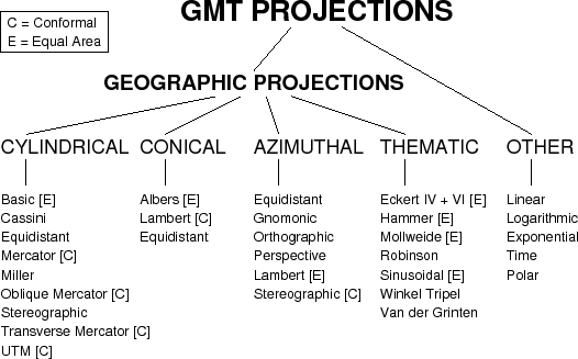
Figure:
The 30+ map projections and coordinate transformations available in GMT.
|
|
The projections available in GMT are presented in Figure 4.5.
For details on all GMT projections and the required parameters, see the psbasemap man page.
We will also show examples of every projection in the next Chapters, and a quick
summary of projection syntax was given in Chapter 3.
Next: 4.4.3 Map frame and
Up: 4.4 Standardized command line
Previous: 4.4.1 Data domain or
Contents
Index
Paul Wessel
2008-05-15